Showing posts with label SLAM. Show all posts

Tuesday, August 4, 2020

LiDAR SLAM Navigatio Resources

https://github.com/teddyluo/LiDAR-SLAM-Nav-RES


LiDAR-SLAM-RES

A page of LiDAR SLAM Navigatio Resources (LiDAR-SLAM-Nav-RES) to follow up current LiDAR SLAM based Navigation trends, including key papers, books, engineering projects, as well as valuable blogs.

(Current) Project III — Motion Planning

ROS Research Papers

  • ROS Layered Costmaps
David V. Lu, D. Hershberger and W. D. Smart, "Layered costmaps for context-sensitive navigation," 2014 IEEE/RSJ International Conference on Intelligent Robots and Systems, Chicago, IL, 2014, pp. 709-715. pdf
  • Layered Social Cost Map
  • Kollmitz, Marina, et al. "Time Dependent Planning on a Layered Social Cost Map for Human-Aware Robot Navigation." 2015 European Conference on Mobile Robots (ECMR). IEEE, 2015. pdf
  • (2019/07/19) David V. Lu, Daniel B. Allan, and William D. Smart. "Tuning Cost Functions for Social Navigation." International Conference on Social Robotics. Springer, Cham, 2013. pdf
  • ROS Navigation Tuning Guide
Kaiyu Zheng, ROS Navigation Tuning Guide. arXiv preprint arXiv:1706.09068v2, Sep. 2016. pdf
  • ROS Navigation: Concepts and Tutorial
Guimarães R L, de Oliveira A S, Fabro J A, et al. ROS navigation: Concepts and tutorial[M]//Robot Operating System (ROS). Springer, Cham, 2016: 121-160. pdf
  • Robotics Engineering 2: ROS-Turtlebot Motion Control and Navigation
AK Assad, Mashruf Chowdhury, and Yanik Porto, Robotics Engineering 2: ROS-Turtlebot Motion Control and Navigation. May 11, 2015. pdf

Books

  • Robotics (Release 1.4)
Jeff McGough, Book title: Robotics. Date: Dec./02/2018. pdf
  • 《机器人操作系统(ROS)史话36 篇》
张新宇, pdf
  • 《人类找北史:从罗盘到GPS,导航定位的过去与未来》
Bray, Hiawatha. You are here: From the compass to GPS, the history and future of how we find ourselves. Basic Books (AZ), 2014. pdf(中文翻译)

Courses

  • 《智能机器人系统》
国防科技大学智能科学学院, 卢惠民,郑志强,韦庆,肖军浩,杨绍武,曾志文, link
  • 《机器人操作系统入门》(2018)
中科院软件所&中科重德机器人公司, 柴长坤, link

Online Resources

Tutorials

  • 机器人操作系统(ROS)暑期学校, type: video&pdf, link
  • 专栏文章:ROS激光SLAM导航(`move_base`参数配置注释), type: blog, link
  • 小强ROS机器人教程, type: pdf, link
  • 机器人操作系统(ROS)浅析, type:pdf, link
  • ROS小课堂, type:blog, link
  • Exbot 易科实验室, link

Projects

  1. PythonRobotics
  2. ROS Navigation Stack

机器人硬件

1) 硬件平台

2) AGV 国家标准

  • 《GB/T 30029 自动导引车(AGV) 设计通则》, pdfpdf(candidate )
  • 《GB/T 30030 自动导引车(AGV) 术语》, pdfpdf(candidate )
  • 《GB/T 20721 自动导引车 通用技术条件》, pdf

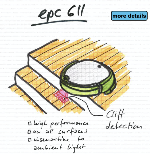
Project I — Hardware Configuration: Laser and IMU Sensors

  1. Laser: Osight LSXXXTM laser sensor configuration & test:
    configuration
  2. IMU:

Project II — Laser-based SLAM (Part 1): Google Cartographer

  1. Google Cartographer
    Hess W, Kohler D, Rapp H, et al. Real-time loop closure in 2D LIDAR SLAM [C]//2016 IEEE International Conference on Robotics and Automation (ICRA). IEEE, 2016: 1271-1278.
  1. Sparse Pose Adjustment (SPA)
    Konolige K, Grisetti G, Kümmerle R, et al. Efficient sparse pose adjustment for 2D mapping[C]//2010 IEEE/RSJ International Conference on Intelligent Robots and Systems. IEEE, 2010: 22-29.
  2. Correlative Scan Matching
    Olson E B. Real-time correlative scan matching[C]//2009 IEEE International Conference on Robotics and Automation. IEEE, 2009: 4387-4393.
  3. Ceres Scan Matching
    Kohlbrecher S, Von Stryk O, Meyer J, et al. A flexible and scalable slam system with full 3d motion estimation[C]//2011 IEEE International Symposium on Safety, Security, and Rescue Robotics. IEEE, 2011: 155-160.
  4. Branch and Bound Algorithm
    Clausen J. Branch and bound algorithms-principles and examples[J]. Department of Computer Science, University of Copenhagen, 1999: 1-30.

Project II — Laser-based SLAM (Part 2): LiDAR SLAM Survey

  1. Castellanos, J.A., Neira, J., & Tardós, J.D. (2005). Map Building and SLAM Algorithms.
  2. Santos, J. M., Portugal, D., & Rocha, R. P. (2013, October). An evaluation of 2D SLAM techniques available in robot operating system. In 2013 IEEE International Symposium on Safety, Security, and Rescue Robotics (SSRR) (pp. 1-6). IEEE.
  3. Mendes, E., Koch, P., & Lacroix, S. (2016, October). ICP-based pose-graph SLAM. In 2016 IEEE International Symposium on Safety, Security, and Rescue Robotics (SSRR) (pp. 195-200). IEEE.
  4. Yagfarov, Rauf & Ivanou, Mikhail & Afanasyev, Ilya. (2018). Map Comparison of Lidar-based 2D SLAM Algorithms Using Precise Ground Truth. 10.1109/ICARCV.2018.8581131.
  5. Felipe Jiménez, Miguel Clavijo and Javier Juana. (VEHICULAR 2018). LiDAR-based SLAM algorithm for indoor scenarios.
  6. Yagfarov, R., Ivanou, M., & Afanasyev, I. (2018, November). Map Comparison of Lidar-based 2D SLAM Algorithms Using Precise Ground Truth. In 2018 15th International Conference on Control, Automation, Robotics and Vision (ICARCV) (pp. 1979-1983). IEEE.
  7. Kümmerle, R., Steder, B., Dornhege, C., Ruhnke, M., Grisetti, G., Stachniss, C., & Kleiner, A. (2009). On measuring the accuracy of SLAM algorithms. Autonomous Robots, 27(4), 387.
  8. Chen, Y., Tang, J., Jiang, C., Zhu, L., Lehtomäki, M., Kaartinen, H., …​ & Zhou, H. (2018). The accuracy comparison of three simultaneous localization and mapping (SLAM)-Based indoor mapping technologies. Sensors, 18(10), 3228.

Areskey Miiboo: ROS Smart Car Platform


A Systematic Platform to Learning Robot Programming with ROS | ROS Smart Car System | SLAM Builds a map | Voice Navigation | Speech Recognition | Speech Synthesis (Package Content: 2)
$99.00
https://www.ienggbdc.com/index.php?main_page=product_info&products_id=486073

https://www.amazon.com/-/es/Platform-construye-Navegaci%C3%B3n-Reconocimiento-S%C3%ADntesis/dp/B07X2HQ23D?th=1

https://www.amazon.com/Platform-Navigation-Recognition-Synthesis-Tutorial/dp/B07X1NMQKT

Brand: Areskey   |   Manufacturer: Miiboo

US$ 528.68
ROS Smart Car Platform | SLAM construye un mapa | Navegación por voz | Reconocimiento de voz | Síntesis de voz | Tutorial de inicio de ROS

This one uses the https://www.ydlidar.com/

https://github.com/miiboo

http://miiboo.cn/


XiaoR GEEK ROS SLAM Robot Car with Laser Radar for Raspberry PI

https://www.xiaorgeek.net/collections/raspberry-pi/products/xiaor-geek-ros-slam-robot-car-with-laser-radar-for-raspberry-pi-4b

XiaoR GEEK ROS SLAM Robot Car with Laser Radar for Raspberry Pi 4B


XIAOR GEEK

$425.99 USD


RPLIDAR A1 Lidar.


https://www.xiaorgeek.net/blogs/news

http://xiao-r.com/Product/page/id/10  Manual

http://xiao-r.com/


Tuesday, July 14, 2020

Cliff detection with ESPRO TOF 8x8 Lidar


https://www.espros.com/wp-content/uploads/2020/07/ESPROS_TOFframe611ForCliffdetection.pdf

Looks like an 8x8 array good for about 2 meters for just under $100 

I am working on get some image of the sensors output in action.


Mobile robots such as vacuum cleaners are safe from falling down stairs - with ESPROS' TOF sensors for cliff detection...

Get in touch with us or order here on Digi-Key.

Also get in contact with our sales partners around the world!

Kind regards,
Your ESPROS Photonics Team


Saturday, September 22, 2018

NaviPack LiDAR Navigation Module


https://www.indiegogo.com/projects/navipack-lidar-navigation-module-reinvented#/

https://www.youtube.com/watch?v=SBhIdXVnoZU&feature=share

https://robot.imscv.com/en/product/3D%20LIDAR


NaviPack makes any device smarter and easier to control. It uses the latest LiDAR technology and powerful APIs to create easy solutions for automated devices.

With the built-in SLAM algorithm chip, Navipack is the first plug-and-play type of LIDAR navigation module. NaviPack is also the most affordable LiDAR solution for drones, robots and other devices and instantly enables them with powerful 360-degree sensing capabilities

NaviPack integrates the SLAM algorithm with the LiDAR sensor module, making it super easy to use and significantly reducing development time.

NaviPack performs 360 degree scanning of its surroundings and all objects up to 15 meters away with a frequency of 4000 points per second. It is super easy to use! With the built-in SLAM module, it will start working immediately after plugging into your devices - scanning the environment, building a detailed map, and enabling auto-moving capability.


 navipack ks explosion.jpg


Saturday, September 5, 2015

Augmented Pixels: Indoor Navigation Platform for Drones

Drones are notoriously difficult to handle indoors: hard to control and prevent crashing into walls or people.

Augmented Pixels has been actively developing technology (including SLAM) to ensure safe flights as well as intuitive and easy navigation using Augmented Reality.

They came up with a platform that significantly reduces accident rates and minimizes the effect of "human factor". Moreover, it is possible to program the drone to fly around and land by itself.


The prospects for this technology include a wide range of use cases (e.g. inspection of premises for security, creation of 360-degree tours, etc.).Augmented Pixels is located in Palo Alto, CA.